About the RMI
The weather radars in Belgium
With four weather radars has Belgium one of the densest radar networks in Europe.
A meteorological radar or weather radar is a measuring instrument that is used for precipitation observations with remote sensing. It is a crucial instrument for weather forecast and observations of the atmosphere.
The RMI has a meteorological radar in Wideumont in the province Luxemburg since 2001. A second radar was installed by the RMI in 2012 in the West-Flemish city Jabbeke to improve the precipitation detection in the North-West of the country. A third radar is run by Skeyes in Zaventem. The newest Belgian radar is in Helchteren and is property of the Flanders Environment Agency (VMM). These four radar cover Belgium optimally for precipitation detection.

The Belgian network of the meteorological radars. Around every radar is a circle of around 100 km. This is the range within a radar can carry out quantitative precipitation estimates. The larger area represents the full range.
What is the use of a meteorological radar?
RMI is using the data from these radars primarily to generate short-term forecasts. Whenever a dangerous weather phenomena announce themselves (such as thunder storms, storms, snowfall) they provide the information to send out a warning. Hydrology is another domain where radar pictures are used in: meteorological radars form a crucial element in forecast systems of the regional hydrological services for flooding. Furthermore, are these data used to make an analysis after heavy rainfall events, that form the basis for the advices given by the RMI to the calamity fund.
The radar of Jabbeke

The radar is installed on top of a concrete tower (height: 46 meter, diameter: 3.7 meter). The sending-and receiving system is located in the metal construction on top of the tower. The parabolic antenna of the radar has a diameter of 4.20 meter and is protected by a white dome-shaped construction of polyester (radar dome) of 6.5 diameter. The radar of Jabbeke is equipped with a dual-polarization technique: measurements take place in vertical and horizontal polarization, which give information about the size and shape of drops, snowflakes or hailstones. This technique gives the opportunity to filter out non-meteorological echoes, like ground echoes, airplanes or birds.
The radar of Wideumont

The radar of Wideumont is located on a metal construction of 50-meter height. Six stable cables insure the stability of the tower. Due to the strategic placement on top of a plateau in the Ardennes it reaches 585 meters above the sea level and it has a free view in all directions.
How does a meteorological radar work?
- A radar is continuously turning and sending thereby electromagnetically pulses (radio waves) out. If these pulses cross a precipitation zone, they are partially reflected and received from the radar. The time between the out-sending of the pulse and the receiving of the reflection gives the distance. This way we know where the precipitation zone is located geographically.
- A radar detects precipitation: rain, snow or hail.
- The antenna scans the airspace in all directions and different angles. The radar gives approximately every 5 minutes a three-dimensional picture of the precipitation in the atmosphere.
- The radar dome protects the radar from wind and rain.


The European radar network
The radars from the RMI and the VMM are part of the European radar network which contains at the moment more than 200 radars. The data from these radars are gathered in real time every 15 minutes and are assembled to one radar image covering whole Europe. This image makes it possible to follow up the development of the precipitation on continental scale.
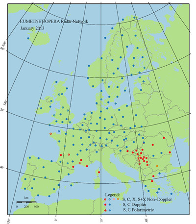
The European radar network (Eumetnet/OPERA)
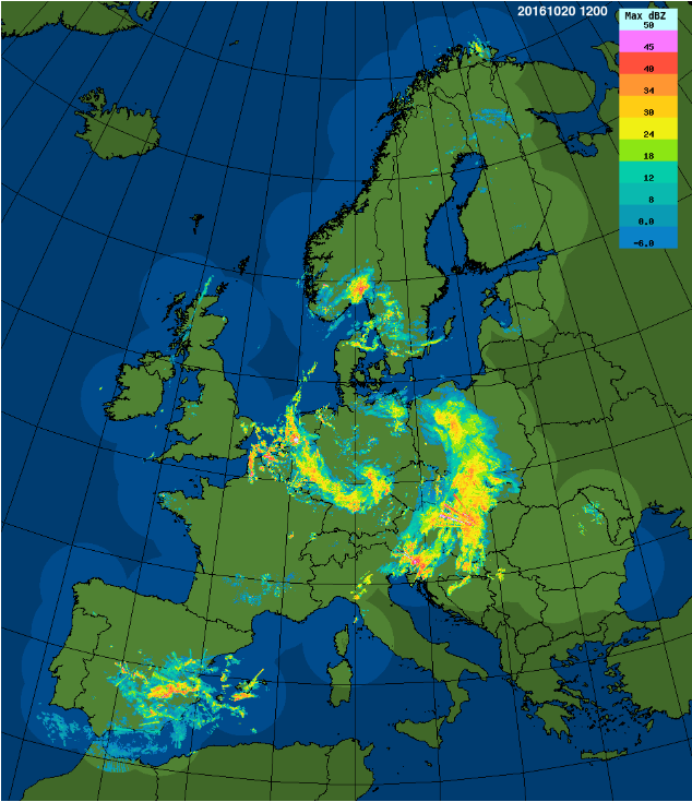
The assembled radar image from Eumetnet/OPERA gives every 15 minutes an overview of the precipitation over Europe
